in support of the 28th Infantry Division
in the vicinity of Vossenack, Germany
2-9 November 1944 - (Rhineland Campaign)
By Major John J Lavin

DISPOSITIONS AND PLANS OF THE 893d T.D. BN.
By the 30th of October the 893d T.D. Battalion, less Co. A and the 1st Reconnaissance Platoon which were on a mission with cavalry troops to the south, had moved into its assigned indirect fire positions to support the attack the following day. The battalion command post and service elements were in the vicinity of MULLARTHUTTE. Co. "B" some 3000 yards northeast, and Co. "C" was located about 2000 yards southeast of the town. The battalion at this time was at full strength in personnel, replacements having arrived while the unit was on a comparatively quiet sector to the south. 11
The battalion also had its full compliment of wheeled and track vehicles, less one tank recovery vehicle. The major supply shortages were in winter clothing, particularly overshoes and gloves. 12 The combat efficiency was considered excellent.
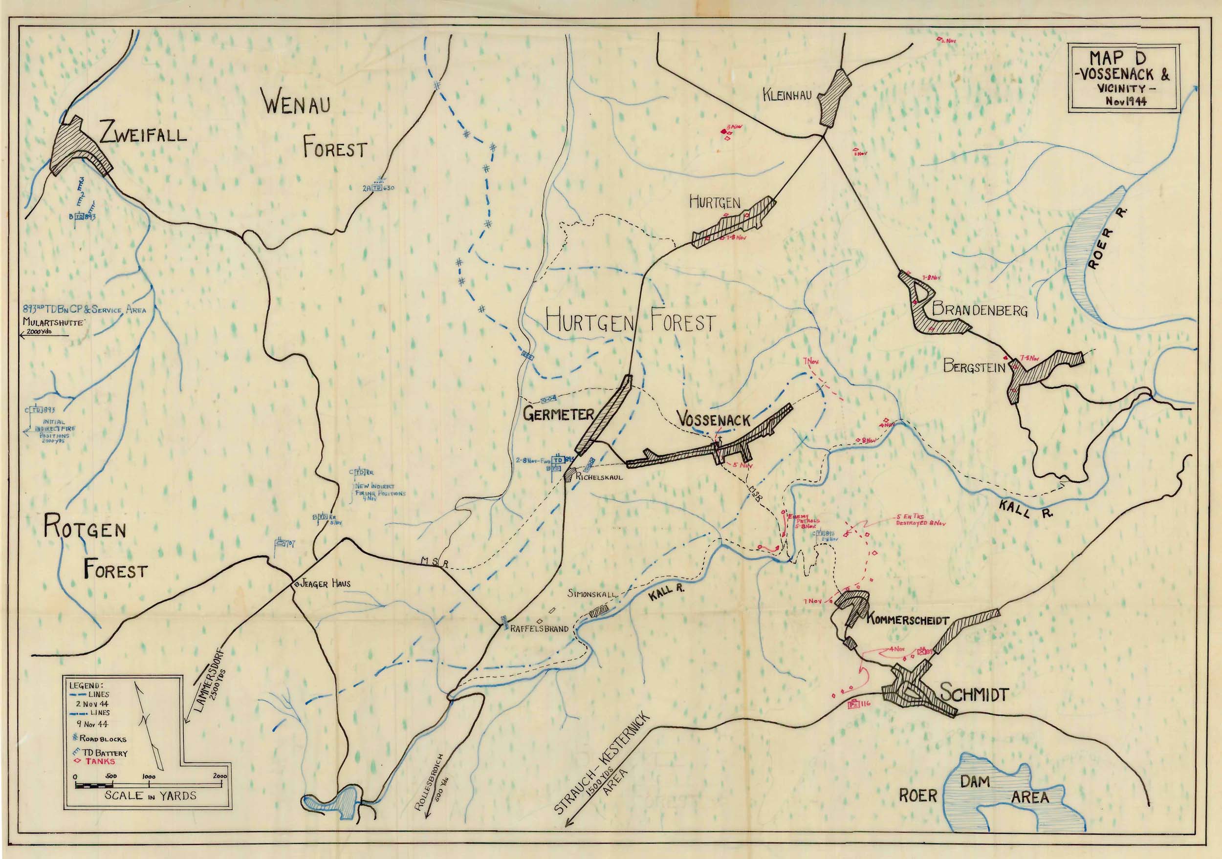
MAP D
The terrain in this area played a critical part in the operation to follow, and deserves further emphasis to assist the reader in obtaining a mental picture of VOSSENACK and vicinity. (See Map D) The forest which covered the entire area, except on the ridges where the villages were located, consisted of pine trees averaging seventy-five feet tall. So dense was their growth that even in broad daylight only a trickle of sunlight filtered through. Cutting the forest up into huge squares were fire lanes and trails. These lanes and trails were soft and soggy from frequent rains. As you emerge from the woods in the vicinity of GERMETER and look generally north to the next clearing part of the town of HURTGEN is seen. Following this ridge around to the east you see the towns of BRANDENBERG and BERGSTEIN.
Next is a sharp drop to the KALL River valley and finally to the southeast the hill on which KOMMERSCHEIDT and a portion of SCHMIDT can be seen. All these towns form a horseshoe of terrain dominating the VOSSENACK 'finger' at a range of about 3000 yards or less. The only paved road in the area runs north to HURTGEN. 13
The gun companies organized their fire direction centers, had their positions surveyed in, prepared fire possibility charts, cleared trees masking their fire and placed the authorized 50 rounds per gun on position. The battalion established liaison with each infantry regiment and division artillery. Wire and radio communications were established within the battalion and tied in with the 630th Tank Destroyer Battalion (Towed). One radio channel was sat on the Division Air O.P. frequency. The firing schedule for the attack the following morning was sent to the gun companies. Although they had not yet registered due to limited visibility they were prepared to fire. 14
There was no enemy armor in the area, however planning for the employment of the battalion in its primary mission was concurrent with the plans and activities necessary to deliver supporting fires. Reconnaissance Company (less 1 platoon w/Co.A) made a reconnaissance of the road net in the division area to determine the most likely routes of enemy tank approach and position areas to counter such moves.
The prevailing bad weather which had prevented the registration of the gun companies also resulted in orders postponing the divisions' attack which was to have taken place the following morning. 15 In spite of the fog, rain and mist which continued throughout most of the operation, the attack was finally ordered for 0900 hours 2 November 1944. 16 The postponement gave all units additional time to perfect plans and study the terrain.