(4TH INFANTRY DIVISION) IN THE HURTGEN FOREST,
GERMANY, 16-22 NOVEMBER 1944
(RHINELAND CAMPAIGN)
By Lieutenant Colonel James W. Haley
TERRAIN ORIENTATION
In order that the reader may better visualize the action that took place, it is deemed desirable to orient him on the Hurtgen Forest, the terrain, and the weather conditions that prevailed during November and December of 1944. All of these factors played a vital role in the actions of the 2nd Battalion, 8th Infantry, and had a direct influence on its successes and failures.
The Hurtgen Forest covers an area of some 50 square miles in the shape of a rough triangle. The points of this triangle are anchored.in the vicinity of Aachen, Düren and Monschau. The forest is a vast expanse of tall, closely packed fir trees and dense hardwood trees. By and large the area is covered with entangled undergrowth though some areas are thinned, out and open. A vast majority of the forest is so dense that the rays of the sun never reach the ground even on a clear day. Reforested plots of small fir trees are scattered through the forest and here the trees are so close to each other and the branches so close to the ground that a man has to crawl on his hands and knees to pass through. The floor of the forest is covered with fir needles and hardwood leaves and is soft and spongy. Numerous fire breaks, straight and narrow, crisscross the entire forest and offer perfect fields of fire for machine guns and anti-tank weapons. Serene and beautiful in peace, the Hurtgen Forest was a cold, damp and depressing hell-hole in the fall and winter of 1944. 18
The terrain in the forest consists of very heavily wooded hills and deep ravines. Numerous small streams and washes drain the area into the Roer River. The hills, though small, are steep and numerous and difficult to negotiate even on foot. Roads are practically non-existent except for the small trails along the fire breaks and these were never meant to sustain military traffic. However, they were the only means of vehicle movement, for the forest was much too dense and the terrain much too rough for cross-country movement. Occasionally small clearings appear in the forest and nearly always these clearings contain small villages such as the village of Hürtgen from which the forest is named. 19
The weather in northwestern Germany in the fall and winter of 1944 was the worst in the memory of this generation of Germans. Never had they seen so much rain nor had it ever been so cold. The rains began early in September and continued almost unceasingly until they turned into sleet and snow early in November. When the rain wasn't falling the clouds persisted and cold fog and mist clung close to the ground. The first heavy snow fell about 10 November and it covered the ground to a depth of four or five inches. It remained on the ground and on the fir trees for three or four days, melting slowly and making the soil even wetter than it was previously. Snow flurries continued through-out November but seldom did the snow last longer than a few hours before it had melted. When it wasn't snowing, it was sleeting and when it wasn't sleeting it was raining. The few days that the sun broke through the clouds and mists could be counted on the fingers of one hand. 20
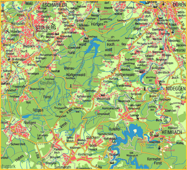
The village of Schevenhütte, Germany lies roughly eight miles southeast of the city of Aachen. (See Map D) It is strung out along a north-south road which winds its way through a deep ravine and is located well into the Hurtgen Forest. The sides of the ravine rise abruptly at an angle of about forty-five degrees. The distance from the road along the bottom of the ravine up the slope to the top is about 500 yards. Here the terrain flattens out somewhat and although the trees are relatively scattered, the undergrowth is exceedingly dense. The surrounding area is rough, heavily wooded and well suited to the defense. All advantage was to be with the Germans because a man moving in a dense forest is much more easily seen than one in a small, well camouflaged, machine gun position.
The thick undergrowth that existed in this area made the prepared positions and barbed wire entanglements practically impossible to locate until the attacker was within ten or fifteen yards of them. The heavy matting of fir needles and leaves on the floor of the forest made it impossible to locate the small wooden Shü Mines.
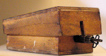
Shü Mine 42
Yes, the Germans knew the importance of the Hurtgen Forest area and recognized its inherent defensive strength. 21